|
Welcome
to Maryland American
History and Genealogy Project
we are in the process of
building new State and County pages for the states where
the coordinator has moved on to other projects. Allegany County is looking for a new Coordinator would you
be interested? If so please contact
Webmaster.
Many of the present coordinators are always willing to give help and
suggestions to newcomers, you can learn, I did and that was after 60!!
Read our
About Page and see what our requirements are,
pretty easy!


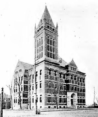
Court House at
Cumberland
Allegany County derives its name from an Indian word,
Alligewi, a tribe name, or Oolik-hanna, meaning "fairest
stream." Its area is 442 square miles, and it lies
between Garrett and Washington, with the Potomac River
separating it from West Virginia on the south. Its
northern line is the Pennsylvania boundary. In this
county is found the narrowest part of the State, and it
is conspicuous by reason of the fact that coal mining
and manufactures give occupation and support to the
great majority of its people, whose number places
Allegany next to Baltimore County in population. The
coal fields cover 64,000 acres in what is known as the
George's Creek (named after Washington) Coal Basin, west
of Cumberland, between Dan's Mountain and Savage
Mountain. The county is rich in other mineral deposits
also, fire clay, cement, iron ore, Medina sandstone,
etc.
The George's Creek Coal Basin is a part of that greatest
of all coal deposits, the Allegheny field, which extends
from Pennsylvania to Alabama. In Maryland the deposit is
of a semi bituminous variety, highly prized for its
peculiar qualities and unrivaled steam-making power.
The limestone and clay lands and the Potomac ''bottoms,"
in parts of Allegany, are exceeding fertile and produce
potatoes, wheat, corn, buckwheat, oats and grass in
large crops. Fruits, especially apples, flourish on the
mountain sides. The county is very progressive and the
standard of education, particularly among the miners, is
high. Vast sums of capital are invested in Allegany
industries, and some of these are among the most
extensive of their kind in the United States. Tin-plate,
leather, cement, lumber, machinery, flour, glass, and
many other products of the county are shipped far and
near.
Next to Baltimore, Cumberland, with a population of
17,128, is the largest city in the State, and is
constantly growing in material resources and size. It is
the business centre of a territory which extends into
Pennsylvania and West Virginia. It is 178 miles from
Baltimore and 149 from Pittsburg, and is reached by the
Baltimore and Ohio, West Virginia Central (of which it
is the eastern terminus) and Cumberland and Pennsylvania
Railroads, the latter a part of the Pennsylvania system.
The Chesapeake and Ohio Canal extends from Cumberland to
Georgetown, 13. C. Fort Cumberland, where Braddock
camped, was the starting point of the present city.
Incident and legend, dealing with Indian, British,
French and Civil Wars, cluster about Cumberland, and the
topography and nomenclature of this region are
suggestive. Frostburg, 17 miles westward of Cumberland,
is a city of 5,274 population, on a plateau at an
elevation of 1,700 feet above sea level. The second
State Normal School is at Frostburg. Lonaconing, a
mining town of 2,181 population, is in southwestern
Allegany; Westernport, Midland, Barton, Mount Savage,
Ocean, Flintstone, Orleans, Pekin are other towns.
Online Here or Other Sites
Maryland
AHGP

Source: History of Maryland, by
L. Magruder Passano, Wm. J.C. Dulany Company, 1901.
|


